Growing demands for faster decision-making and real-time situational awareness are changing how organizations deploy unmanned aerial vehicles. Traditional cloud-based workflows often require large amounts of data to be transmitted before analysis, creating delays that can limit operational efficiency. As industries such as emergency response, surveying, and intelligent monitoring adopt advanced UAV solutions, drone edge computing is becoming a key technology for processing information closer to the source and enabling faster, smarter operations.
The Limitations of Cloud-Based Drone Data Processing
For many years, UAV systems have relied on cloud pipelines to process captured images, videos, and sensor information. In this model, drones collect data in the field and transmit large volumes of information to remote servers for analysis. While cloud platforms provide strong computing resources, this approach can create challenges in environments where network conditions are unstable or immediate decisions are required.
Large-scale drone missions generate massive datasets, especially when performing high-resolution mapping, 3D reconstruction, or continuous monitoring. Transmitting all raw data can consume significant bandwidth and increase operational costs. Delays between data collection and analysis may also reduce the value of information in time-sensitive applications.
These challenges have accelerated the adoption of drone edge computing, which enables UAV platforms to analyze data directly during missions instead of depending entirely on remote cloud infrastructure.
Why Drone Edge Computing Is Becoming Essential for Modern UAV Applications
Drone edge computing brings computing capabilities closer to the data collection point. By integrating intelligent processing units into UAV systems, drones can analyze images, identify targets, and generate valuable outputs while still operating in the field.
This approach optimizes response speed and reduces dependency on continuous high-bandwidth connections. For industries managing complex environments, such as disaster monitoring, infrastructure inspection, and large-scale surveying, real-time processing provides a significant operational advantage.
Beyond faster data handling, edge intelligence allows UAV systems to become more autonomous. Instead of simply collecting information, drones can interpret conditions, adjust tasks, and support decision-making during operations.
Drone Data Analytics Enables Real-Time Intelligence from the Field
Effective UAV operations depend not only on collecting information but also on extracting meaningful insights. Advanced drone data analytics transforms raw aerial data into actionable intelligence through AI-powered recognition, positioning, and modeling technologies.
Icecypress Technology develops spatial intelligence AI solutions that combine 3D technologies, artificial intelligence, and UAV capabilities. Its DroneSwarm Real-Time Onboard Analysis System is designed to support precision drone data acquisition and real-time monitoring through intelligent edge processing.
The system enables multi-UAV collaborative real-time 2D and 3D mapping, reconstruction, target recognition, positioning, and tracking. By integrating drone edge computing across operations, DroneSwarm creates a more efficient workflow where data collection, processing, and analysis can happen within a unified platform.
Building Smarter UAV Tracking and Positioning Through Air-Ground Collaboration
Reliable UAV tracking and positioning are essential for coordinated drone operations, especially when multiple aircraft work together across complex environments. Traditional systems may experience limitations when communication links are unstable or when large amounts of data need to be transferred before analysis.
DroneSwarm builds an integrated UAV tracking and UAV positioning system through a multi-tiered architecture that combines onboard processing with ground-based management. The platform supports seamless integration of Communication, Navigation, and Control (CNC), creating a closed-loop operation process across the entire UAV swarm.
Through onboard intelligence and centralized coordination, the system optimizes mission reliability. UAVs can maintain accurate positioning information, share operational data, and support coordinated actions without depending solely on external processing resources.
Real-Time Mapping and 3D Reconstruction with Embedded Computing
One of the major advantages of drone edge computing is the ability to produce valuable outputs during flight. Traditional workflows often require data collection first, followed by lengthy post-processing stages. Edge-based systems reduce this waiting period by performing analysis directly on embedded platforms.
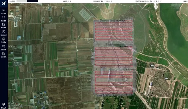
DroneSwarm supports real-time orthophoto mapping through its embedded processing capabilities. The system can fly, process, and transmit simultaneously, generating digital orthophoto maps (DOM) during missions without requiring additional post-processing. Its embedded global bundle adjustment technology helps correct image distortions, shadows, and overlaps while maintaining centimeter-level accuracy.
The platform also optimizes communication efficiency by transmitting processed results instead of large volumes of raw data. This significantly reduces communication pressure and helps UAV operations continue in challenging environments with limited connectivity.
For large-scale modeling tasks, DroneSwarm uses multi-UAV collaboration and distributed parallel computing to accelerate 3D reconstruction. Complex survey areas can be modeled rapidly after missions, while close-range imaging supports detailed reconstruction of important targets.
Improving Target Recognition and Decision-Making with AI-Powered UAV Systems
Modern UAV applications increasingly require more than mapping capabilities. Organizations need systems that can recognize objects, track changes, and provide accurate location information in real time.
DroneSwarm integrates intelligent recognition and positioning technologies to support advanced drone data analytics. The system can identify multiple categories of targets, including time-sensitive, static, and environmental objects, with high recognition accuracy.
By combining GPS data with visual SLAM positioning technology, the platform enables precise UAV tracking and coordinate transmission. It also supports change detection by comparing multi-temporal DOM and 3D models, helping organizations identify modifications such as new structures or infrastructure changes.
These capabilities allow UAV systems to move from passive observation toward active intelligence, providing stronger support for monitoring, inspection, and emergency operations.
Advancing UAV Intelligence Through Edge-Based Innovation
The transition from cloud-dependent workflows to intelligent onboard processing represents a major evolution in UAV technology. As industries require faster responses, better reliability, and more efficient data management, drone edge computing provides a practical foundation for next-generation aerial intelligence.
Icecypress Technology’s DroneSwarm system demonstrates how onboard AI, multi-UAV collaboration, and advanced drone data analytics can work together to create smarter operational solutions. By combining real-time processing, accurate positioning, and intelligent decision support, the technology helps organizations unlock greater value from UAV deployments and build more responsive air-ground collaboration systems.
